What Will Tomorrow’s Residential Climate be Like?
What Will Tomorrow’s Residential Climate be Like?
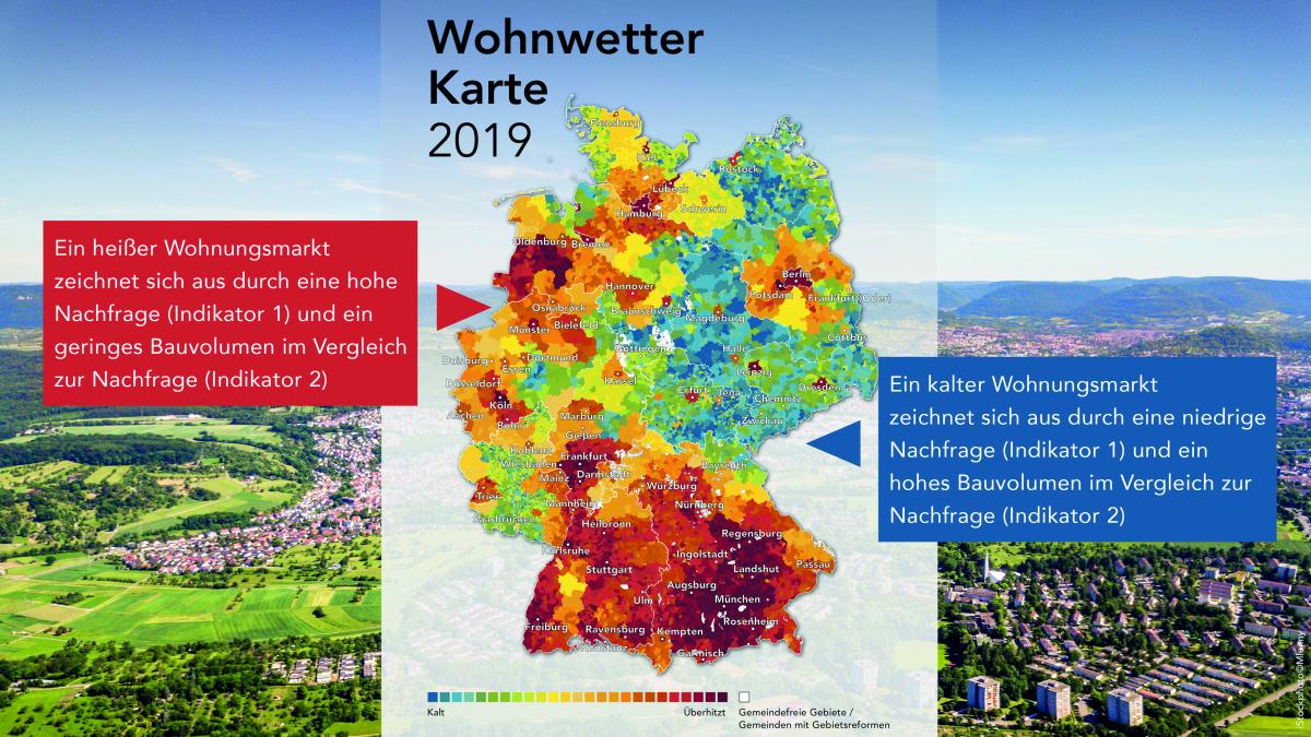
In collaboration with our client BPD, we analysed the situation on Germany’s housing market. The findings for 11,000 communities are represented in an interactive housing weather map. It shows clearly: The map covers the whole spectrum from “hot” to “cold” – and some locations will surprise you.
The housing weather map captures the current state on the housing markets of around 11,000 German towns. It graphically displays the housing market “temperature” for each town while also providing an outlook for the next three to five years. An important indicator is the housing demand (replacement, additional, pent-up demand), which is put in relation to the current construction volume, among other factors. A “hot” housing market is defined by keen demand and a low-level construction volume relative to demand. “Cold” means that demand for housing is slow or else that the building activity is too fast-paced relative to demand. In other words, “hot” is neither synonymous with “good” nor “cold” with “poor” – what counts in either case is the outlook.
The housing weather map illustrates transparently how heterogeneous the German housing market is. As is well known, many large cities face the enormous challenge that building land shortages pose. But it is often overlooked that excess supply is building up in some regions. The different temperatures shown on the housing weather map are also to blame on a misguided distribution of the construction activity in Germany. In large parts of Saxony, Saxony-Anhalt, Saarland as well as in southern and eastern Lower Saxony, the construction activity is excessive. Conversely, numerous major German cities as well as certain regions, particularly in southern Hesse, southern Bavaria and large parts of Baden-Württemberg, show a shortfall in completions. The challenge posed by the imbalance cannot be resolved except by stepping up the building activity in conurbations and better transport links between “warm” and “cold” regions.
Five Housing Weather Trends
A look at the weather map shows five main trends that best describe the housing weather in Germany:
1. Hot in the South, Cold in the East
When you look at the greater picture, Germany shows a gradient: Southern Germany boasts substantial incoming migration – the majority of very hot districts lies inside a radius of 100 kilometres of Munich. The weather in western and northern Germany is mixed, whereas large tracts of eastern Germany are cold. This pattern has existed for a long time – so it would be more apt to call it housing climate rather than housing weather.
2. Major Cities and University Towns Are Hot Spots
Major cities show a particularly wide discrepancy between demand and supply. In the cases of Munich and Stuttgart, the development extends deep into the wider region. This contrasts with the situation in Berlin, Frankfurt, Cologne, Düsseldorf, Hamburg and Bremen where the effect is more conspicuous in the cities proper and their suburbs. The housing weather map also identifies smaller cities that are too hot, including Kiel, Rostock, Münster, Karlsruhe and Freiburg. Housing markets here are stimulated mainly by the economically stronger regions they are located in and by a large number of students.
3. West German Hill Country on a Level with Rural Eastern Germany
In the low-elevation mountain ranges of western Germany, including Sauerland, Vogelsberg, Hunsrück and Eifel, the thermometer matches the temperature level of rural East Germany. Analogously, the mountainous areas of Black Forest, Odenwald, Spessart and Bayerischer Wald are noticeably cooler than their surrounding regions. The low demand in these regions can probably be blamed on the comparatively poor transportation access.
4. Even Rural Regions Are under Pressure
In the countryside, the weather situation represents a mixed bag and contrasts with that of major cities and university towns. In most rural regions, the building activity is higher than the slow demand would warrant. Then again, some regions take exception to the rule, such as Emsland-Cloppenburg-Vechta, Konstanz-Tuttlingen-Balingen and Ulm-Oberschwaben-Allgäu, where high birth rates and a prospering mid-market economy generate a strong demand for residential accommodation.
5. Neighbours Helping to Generate Heat
Above-average temperatures were also registered in the border regions of the Netherlands, Luxembourg and Switzerland. These thrive on spill-over effects from the robust economic performance and in some cases from the overheated markets on the far side of the German border.
Note: You will find the interactive housing weather map and additional details on the homepage of BPD (German). The map will be updated next in 2020 and again in 2021.
Contact person: Felix Embacher, Head of Division for Master Planning and Special Housing Types at bulwiengesa, embacher [at] bulwiengesa.de


